
🗺️Les plans à télécharger et à imprimer
Le Resort de Disneyland Paris est immense et s’étend sur plus de 22km². Pour ne pas vous perdre entre le Château de la Belle au Bois Dormant et le nouveau Disney Adventure World, une bonne préparation est indispensable. Voici à votre disposition les plans de toutes les zones de Disneyland Paris. Ces cartes indiquent toutes les attractions disponibles mais également les lieux importants comme les endroits de spectacles, les hôtels, les accès piétons etc. En cliquant sur un plan, vous obtiendrez le plan en plus grande qualité.
Une fois le fichier télécharger, vous devez le décompresser. Les plans sont au format pdf et peuvent facilement être imprimés. Si besoin, télécharger le logiciel Acrobat Reader gratuitement pour visualiser les plans.
📍 Avoir le plan, c’est bien. Avoir la stratégie, c’est mieux !
Le plan vous montre où sont les attractions, mais il ne vous dit pas comment éviter 60 min d’attente à chacune d’entre elles.
Mon guide stratégique 2026 complète parfaitement ce plan avec :
- 🛡️ Mes techniques pour ne pas faire la queue sans dépenser un centime de plus.
- ⏱️ Mes plannings optimisés pour 1 jour ou 2 jours de visite.
- 💰 Les zones de restauration secrètes pour manger mieux et moins cher sur le pouce.
🏠 Où se situer pour minimiser la marche ?
Regardez attentivement le plan des hôtels Disney. Beaucoup de visiteurs font l’erreur de choisir un hôtel éloigné pour économiser quelques euros, sans réaliser qu’ils devront marcher 20 minutes supplémentaires ou dépendre des navettes.
- Hôtels à moins de 10 min à pied : Disneyland Hotel, Hotel New York – Art of Marvel.
- Le meilleur compromis : Le Newport Bay Club ou le Sequoia Lodge.
Vous n’avez pas encore réservé ? Utilisez mon comparateur pour voir si un séjour hôtel + billets n’est pas plus rentable que vos billets seuls.
Billet seul ou Séjour Hôtel ?
Comparez le coût pour votre famille en 2026
Billets seuls
- ❌ Nuitée non incluse
- ❌ Billets 2 jour(s)
- ❌ Parking : 60€
Séjour Hôtel Disney
- ✅ 1 nuit incluse (Disney Hotel Santa Fe)
- ✅ Billets inclus pour 2 jours de parcs
- ✅ Parking GRATUIT
- ✅ Heures de Magie en Plus
Pour seulement 96€ d'écart, offrez-vous la nuit à l'hôtel Disney et 2 jours de parcs !
Vérifier les disponibilités 2026*Tarifs indicatifs basés sur le Disney Hotel Santa Fe en basse saison 2026.
💡 L’astuce pour ne plus avoir besoin de plan
Si le plan papier est utile pour annoter vos attractions favorites, il ne vous donne pas une information capitale : le temps d’attente.
Pour optimiser votre journée, nous vous recommandons d’utiliser en complément l’application officielle Disneyland Paris. Elle propose une carte interactive avec géolocalisation pour vous guider en temps réel entre les attractions et consulter les horaires de fermeture.
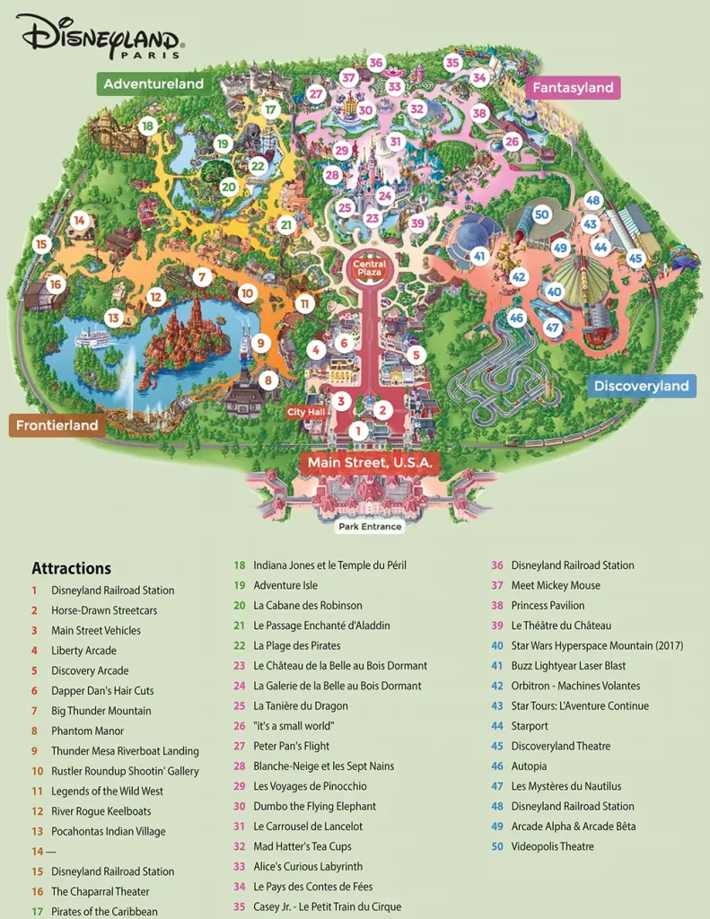
Plan du Disneyland Parc
Cliquez pour zoomer. Comprends la liste des attractions classées par land et par couleur. Vous arrivez par Main Street U.S.A., puis dans l’ordre des aiguilles d’une montre: Frontierland, Adventureland, Fantasyland, Discoveryland avec au centre Central Plaza
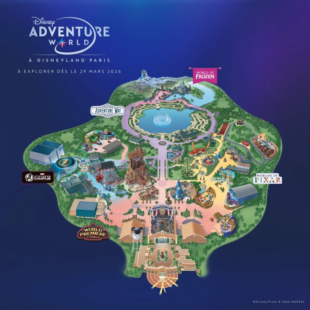
Plan du parc Disney Adventure World
Cliquez pour zoomer. Cartes complètes du parc, avec l’ajout des nouvelle attractions et du Avengers Campus, World of Frozen, Adventure Way et Worlds of Pixar, avec évidemment le passage obligé par World Premiere Plaza.
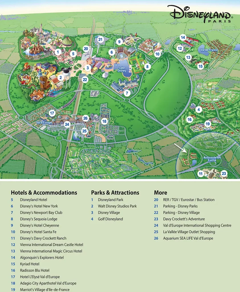
Plan du complexe Disneyland
Cliquez pour zoomer. Carte de l’ensemble de Disneyland Paris. Cela vous permet de voir les emplacements de tous les parcs, des hôtels, de la gare et des accès routiers.
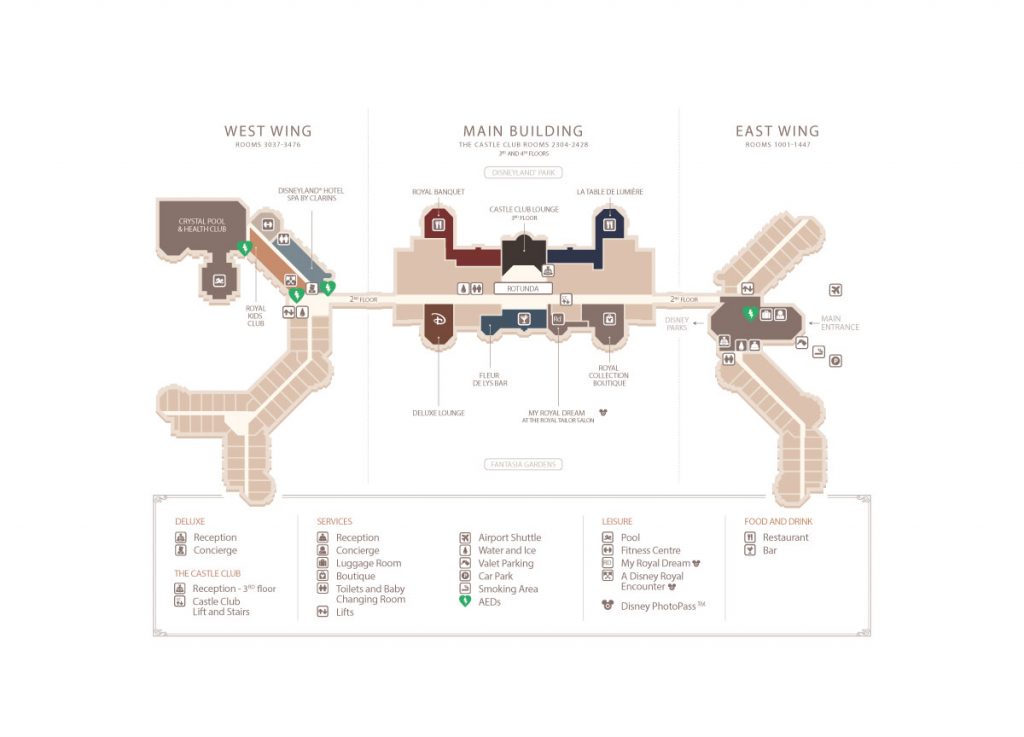
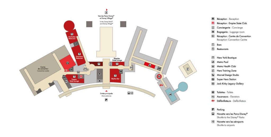
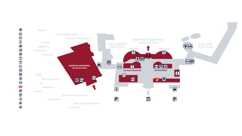
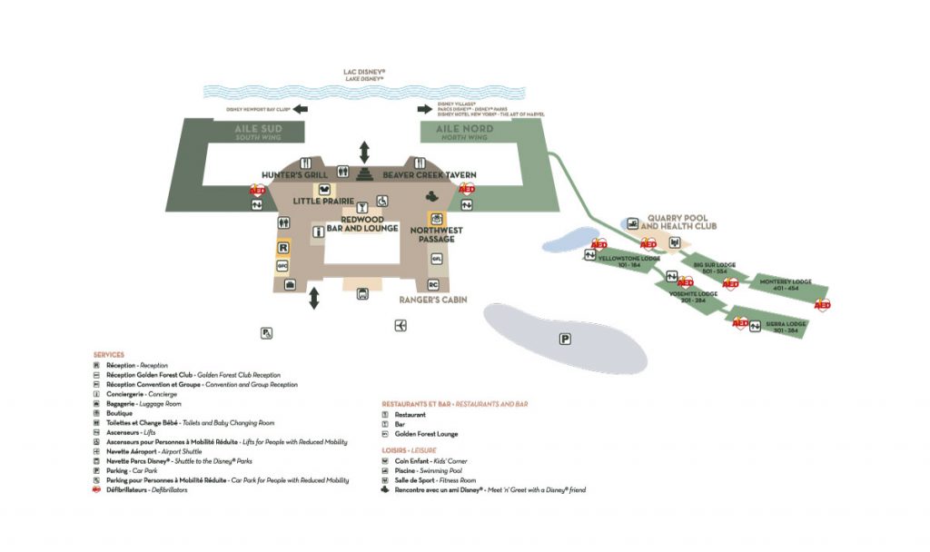
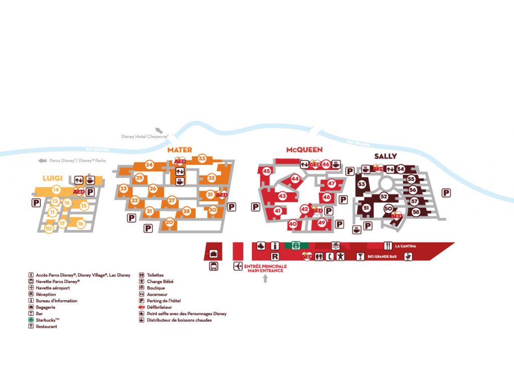
Plan des hôtels Disney
Toutes les informations sur les hôtels ici. utile pour retrouver son chemin
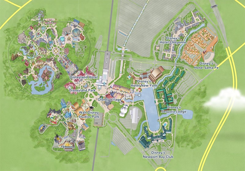
Disneyland Hotel
Hotel New York The Art of Marvel
Hotel Newport Bay Club
Hotel Sequoia Lodge
Hotel Cheyenne
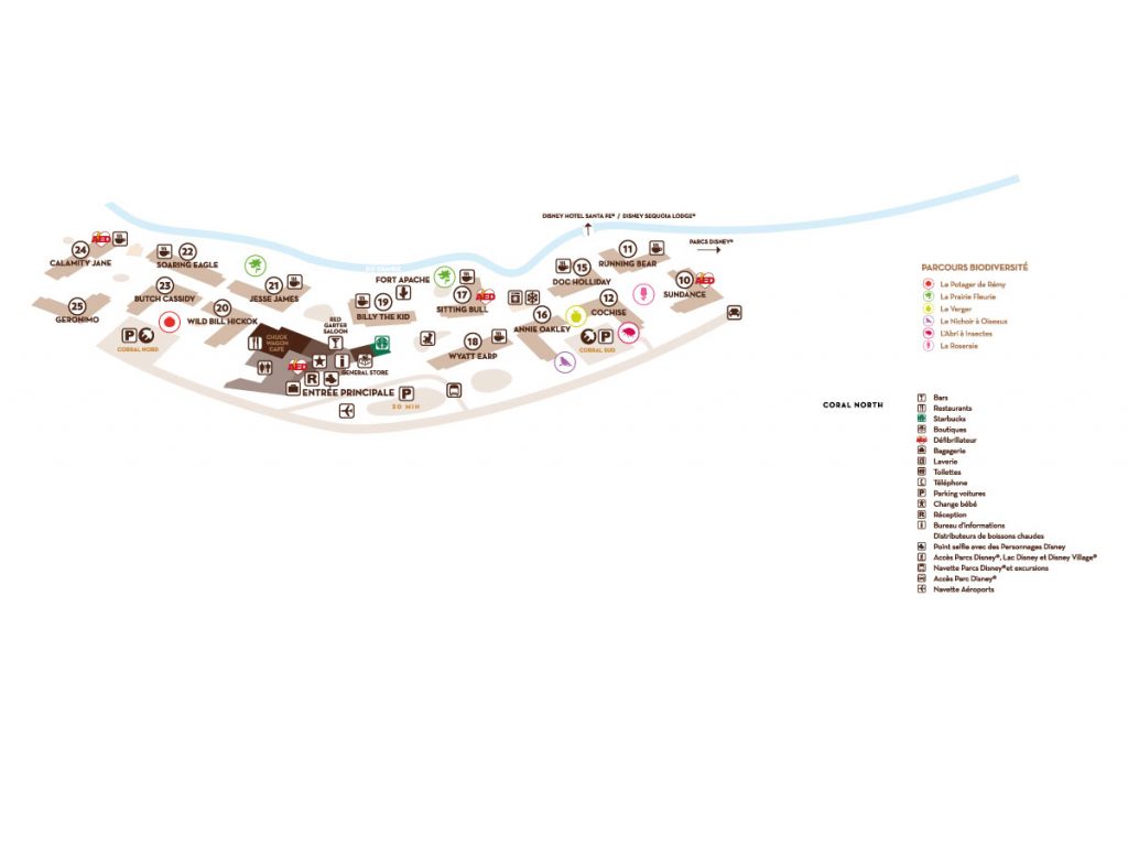
Hotel Santa Fe
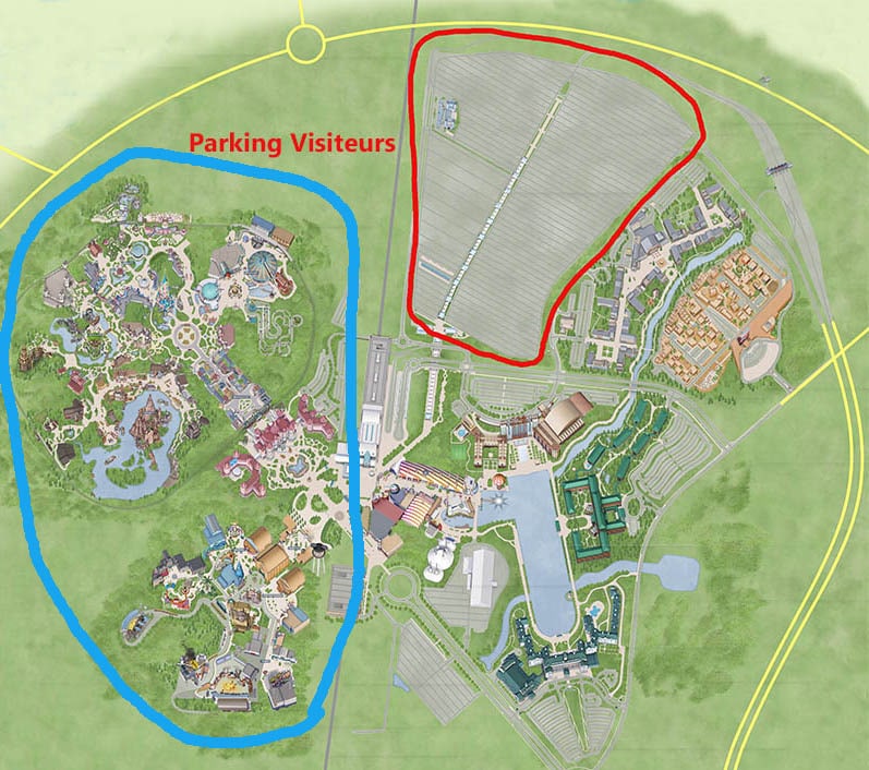
Carte du parking Eurodisney
Toutes les informations sur le parking Disney ici
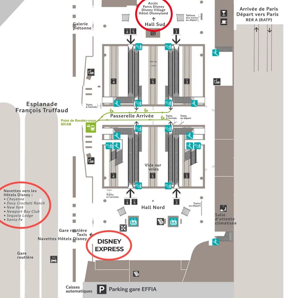
Plan de la gare de Marne la Vallée Chessy
Plan hyper utile si vous allez à Disneyland Paris en RER. Avec emplacement de la bagagerie Disney Express (au premier étage)
La carte interactive de l’application Disneyland Paris
Gratuitement, vous pouvez télécharger l’applciation sur votre mobile. Celle-ci contient une carte interactive très pratique. Ce plan, portable vous permet, grâce à la géolocalisation de vous guider entre ls attractions. Cette carte permet également de connaitre les horaires et temps d’attentes estimés.


FAQ : Tout savoir sur l’orientation à Disney
Oui, des plans sont disponibles gratuitement aux guichets et à City Hall (Parc Disneyland) ou Studio Services (Disney Adventure World). Cependant, les imprimer à l’avance vous permet de marquer vos priorités avant d’arriver dans la foule.
Nos PDF incluent les 5 lands du Parc Disneyland (Main Street U.S.A, Frontierland, Adventureland, Fantasyland, Discoveryland), ainsi que le Disney Village et les zones hôtelières.
Le parking visiteur est immense. Utilisez le plan du parking pour repérer le tapis roulant qui vous déposera directement aux portes des parcs.

Passionné, Auteur et Guide indépendant